This feature highlights a selection of the aerial photographs of Scotland taken by the German Luftwaffe during the Second World War. German aerial reconnaissance of Scotland was first carried out in 1938, when concealed cameras were mounted in civilian Lufthansa aircraft which ranged across Europe, from Ireland to the Baltic, under the guise of checking potential air routes. During the Second World War, various types of German reconnaissance aircraft overflew Scotland from bases in Norway and Denmark, with collection rates declining from 1943 onward, as defending fighters attained greater performance and German priorities changed following the cancellation of plans to invade Britain.
The images featured here are some of the target graphics created from the original reconnaissance photographs - they have been cropped and annotated with intelligence information by German photographic interpreters and were recovered from various locations across Europe in the last days of the war.
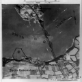
Forth Bridge
Taken before 2 October 1939, this image of the Forth Bridge may have served as an intelligence source in the planning of the first German air attack on Scotland of the Second World War, on 16 October 1939. Details of the fabric of the bridge and the position of anti-aircraft and coastal defence batteries are noted on the graphic. The shape and construction of the cantilever rail bridge is clearly revealed by its shadow.
|
 |
Scapa Flow
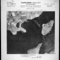
In the early hours of 14 October 1939, the German submarine U-47, commanded by Lt Gunther Prien, slipped between the blockships of Kirk Sound and sank HMS Royal Oak, at anchor in Scapa Flow. This image, taken almost a year later, on 8 October 1940, shows the location of several elements in the Orkney defences developed after that episode: two anti-aircraft batteries west of St Mary's and a military camp to the east, coastal defence gun batteries on Burray and Lamb Holm and the extended chain of blockships in Kirk and Holm Sounds.
|
 |
Hillington
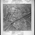
Defended by three barrage balloons (annotated 'a'), this image shows the Rolls Royce aero-engine factory at Hillington on 23 March 1941. This factory manufactured engines for Spitfire fighters, among other types, and was vital to the British war effort. A housing scheme under construction is visible to the south of the factory and anti-glider obstacles can be seen in fields to the north.
|
 |
Ardeer
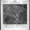
This image of the ICI explosives works at Ardeer and the Royal Ordnance Factory at Irvine, sites which do not appear on any contemporary maps, was taken on 9 January 1941. Twelve barrage balloons are visible, protecting the sites from low-level aerial attack. Plumes of smoke can be seen, rising from the power station and chemical works at the heart of each site, blown by the north-easterly wind.
|
 |
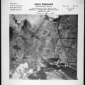
Rannoch
Very early in the Second World War, the Luftwaffe had collected aerial photography of large tracts of the British Isles, as their reconnaissance aircraft were able to operate at heights far above the ceiling of British fighters. This image of the Rannoch hydro-electric power station was taken on 24 September 1940 and the key elements of the scheme were carefully annotated by photographic interpreters.
|
 |
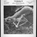
Benbecula
Developed as a pre-war civilian airport and subsequently used by RAF Coastal Command for anti-submarine patrols in the North Atlantic Ocean, this airfield was under extension when this photograph was taken on 6 August 1941.
|
 |
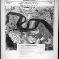
Alloa
The Royal Naval Armaments Depot at Throsk, near Alloa, is comprehensively detailed in this image of the upper Forth, taken before 2 October 1939. Also visible in this image is the former railway swing-bridge at Throsk, which was demolished in 1971.
|
 |
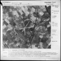
RAF Dyce
Now Aberdeen International Airport, RAF Dyce was occupied by Hawker Hurricane fighters of 145 Squadron, Royal Air Force, when this image was taken on 21 September 1940. A number of aircraft can be seen on the eastern side of the airfield, where a civilian airport was first established in 1934 (numbered '10' on the image). In the north-western corner of the airfield, neat rows of bell-tents (numbered '8') are situated adjacent to the foundations of more permanent accommodation buildings, under construction.
Later in the Second World War, Dyce was home to 8 Operational Training Unit, which trained crews for photographic reconnaissance work. The station remained in RAF use until 1957.
|
 |
RAF Drem
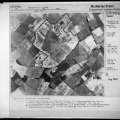
Three grass runways are visible in this image of RAF Drem, taken on 22 July 1940. Used intermittently from 1916 to 1939, Drem served as a fighter and night-fighter station during the Second World War before closing in 1946. The thoroughness of much German photographic interpretation work is illustrated by this image, where each aircraft dispersal pen and four defensive pillboxes are noted.
|
 |
Kyle of Lochalsh
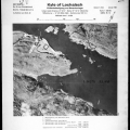
The western seaboard of Scotland was an important haven for convoys and warships alike during the Second World War. Three vessels are visible in this image from 29 September 1940, anchored in the sheltered waters of Loch Alsh and protected by a coastal gun battery (annotated '1').
|
 |
RAF Skeabrae
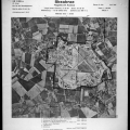
Though appearing to be under construction when this image was taken, on 2 May 1941, Skeabrae was opened to aircraft in October 1940. It exhibits contrasting tactical awareness in that blister hangars for aircraft are well dispersed around the site in groups of three, to reduce the risk of destruction from enemy attack, while the accommodation and technical buildings are grouped tightly together on the western perimeter.
The only RAF station in Orkney, Skeabrae was reduced to Care and Maintenance status after the Second World War and closed in 1957.
|
 |
Aberdeen
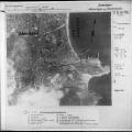
During the Second World War, Aberdeen was a vital harbour for warships operating in the North Sea, as well as merchant ships moving around the coastline of the UK. It was also the location for important shipbuilding and repair facilities, which have been identified and annotated on this image from 14 September 1940. German photographic interpreters made one error, however; whilst they identified a gun battery on the coastline to the east, they did not recognize that the adjacent Torry fort housed an additional two guns.
|
 |
Clydebank
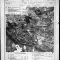
Annotated with intelligence information on 2 October 1939, this target graphic for Clydebank focusses on the John Brown & Co. shipyard (annotated 'A'), where the Queen Elizabeth can be seen, jutting out beyond her fitting-out basin into the River Clyde.
|
 |
Download the Catalogue of Luftwaffe Photographs in the National Monuments Record of Scotland (RCAHMS 1999)


